|
 Disclaimer: External data. HolaCuba assumes no liability.
Date:
Tue, 09 Jun 2026 04:20:34 GMT
Quelle: NHC Atlantic
Mehr Info und aktuelle Karten
No Hurricanes [Spanish: ciclon] are reported in the Caribbean Region at this time.

 That's how it starts:
the first raindrops are already there
Hurricanes are tropical cyclones. Danger arises through very high wind speeds,
waves and heavy rainfalls. In Cuba a common word for a hurricane is 'ciclon'. Season is
from May through November. Traditionally, through its well organized system of civil protection Cuba
is better prepared for hurricanes then the USA or other countries of the Caribbean. Cuba suffers less
loss of human life. Is is not safe from substantial material damages though.
Are you there? Something happens?
Report it on HolaCuba right here:
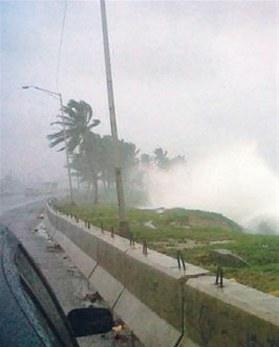
Right: typical photo of a hurricane
Thank you for the picture, Andrew
(was our guest in
Varadero)
We are frequently asked: How are we supposed to behave as a tourist
when we get surprised on the island?
Two simple rules:
1. Stay home.
2. Follow the orders of the Civil Protection authorities.
All our Casas have a solid construction base, none is made of wood.
Hurricane damages
 After the ciclon:
Construction materials are paramount
Oficially a hurricane starts when wind speed exceeds 118 Km/hour. But even at 50 Km persons are adviced to seek protection.
Aus der Schweiz könen Sie Ihre Hilfe für die Opfer direkt an
Cuba-Si Schweiz
leisten.
More about hurricanes in Wikipedia
(This page is searched for and found in the web
as 'hurrican cuba' but also as 'hurricane kuba'.)
Historic Tropical Storms / Hurricane names in 2011: Bret Irene Ophelia Katia
In 2010: Agatha Earl
In 2009: Ana, Hurricane Bill, Claudette, Danny, Fred, Ida
|
 Payments in bitcoins for accommodation in Cuba accepted here.