|
 Disclaimer: External data. HolaCuba assumes no liability.
Date:
Wed, 17 Jun 2026 09:06:11 GMT
Quelle: NHC Atlantic
Mehr Info und aktuelle Karten
 Wind Speed Probabilities last updated Wed, 17 Jun 2026 08:41:10 GMT
000 ABNT20 KNHC 170544 TWOAT Tropical Weather Outlook NWS National Hurricane Center Miami FL 200 AM EDT Wed Jun 17 2026 For the North Atlantic...Caribbean Sea and the Gulf of America: Active Systems: The National Hurricane Center is issuing advisories on Potential Tropical Cyclone One, located near the middle Texas coast. * Formation chance through 48 hours...medium...60 percent. * Formation chance through 7 days...medium...60 percent. && Public Advisories on Potential Tropical Cyclone One are issued under WMO header WTNT31 KNHC and under AWIPS header MIATCPAT1. Forecast/Advisories on Potential Tropical Cyclone One are issued under WMO header WTNT21 KNHC and under AWIPS header MIATCMAT1. $$ Forecaster Hagen
...LOW PRESSURE SYSTEM MOVING NORTHEASTWARD ALONG THE MIDDLE TEXAS COAST... ...EXPECTED TO CAUSE LIFE-THREATENING FLOODING ACROSS PORTIONS OF THE SOUTHEASTERN UNITED STATES... As of 4:00 AM CDT Wed Jun 17 the center of One was located near 28.0, -96.7 with movement NE at 6 mph. The minimum central pressure was 1003 mb with maximum sustained winds of about 30 mph.
Issued at 400 AM CDT Wed Jun 17 2026 000
WTNT31 KNHC 170835
TCPAT1

BULLETIN
Potential Tropical Cyclone One Advisory Number   4
NWS National Hurricane Center Miami FL       AL012026
400 AM CDT Wed Jun 17 2026

...LOW PRESSURE SYSTEM MOVING NORTHEASTWARD ALONG THE MIDDLE TEXAS
COAST...
...EXPECTED TO CAUSE LIFE-THREATENING FLOODING ACROSS PORTIONS OF
THE SOUTHEASTERN UNITED STATES...


SUMMARY OF 400 AM CDT...0900 UTC...INFORMATION
----------------------------------------------
LOCATION...28.0N 96.7W
ABOUT 35 MI...55 KM SW OF PORT OCONNOR TEXAS
ABOUT 255 MI...410 KM SW OF LAKE CHARLES LOUISIANA
MAXIMUM SUSTAINED WINDS...30 MPH...45 KM/H
PRESENT MOVEMENT...NE OR 45 DEGREES AT 6 MPH...9 KM/H
MINIMUM CENTRAL PRESSURE...1003 MB...29.62 INCHES


WATCHES AND WARNINGS
--------------------
CHANGES WITH THIS ADVISORY:

None.

SUMMARY OF WATCHES AND WARNINGS IN EFFECT:

A Tropical Storm Warning is in effect for...
* Sabine Pass to Morgan City

A Tropical Storm Watch is in effect for...
* Sargent to Sabine Pass

A Tropical Storm Warning means that tropical storm conditions are
expected within the warning area, in this case within 12 to 24
hours.

A Tropical Storm Watch means that tropical storm conditions are
possible within the watch area, in this case within 12 hours.

For storm information specific to your area, including possible
inland watches and warnings, please monitor products issued by your
local National Weather Service forecast office.


DISCUSSION AND OUTLOOK
----------------------
At 400 AM CDT (0900 UTC), the disturbance was centered near latitude
28.0 North, longitude 96.7 West. The system is moving toward the
northeast near 6 mph (9 km/h), and an increase in forward speed is
expected today.  On the forecast track, the low pressure area
should move northeastward along the Texas coast today and then move
inland over southwestern Louisiana by tonight.

Maximum sustained winds are near 30 mph (45 km/h) with higher gusts.
Some strengthening is forecast, and the disturbance could become a
tropical storm today.  Weakening is anticipated once the low moves
inland, and it could dissipate by tonight or early Thursday.
* Formation chance through 48 hours...medium...60 percent.
* Formation chance through 7 days...medium...60 percent.

The minimum central pressure based on surface observations is 1003
mb (29.62 inches).


HAZARDS AFFECTING LAND
----------------------
Key messages for Potential Tropical Cyclone One can be found in the
Tropical Cyclone Discussion under AWIPS header MIATCDAT1 and WMO
header WTNT41 KNHC.

RAINFALL: Potential Tropical Cyclone One is expected to produce
rainfall totals of 5 to 10 inches, with isolated higher totals near
20 inches, through early Friday from the Mid and Upper Texas coast
east-northeast into southern and central portions of Louisiana,
Mississippi, and Alabama, along with western portions of Georgia and
the Florida Panhandle. This could generate dangerous to
life-threatening flash flooding.

For a complete depiction of forecast rainfall associated with
Potential Tropical Cyclone One, please see the National Weather
Service Storm Total Rainfall Graphic available at
hurricanes.gov/graphics_at1.shtml?rainqpf and the Flash Flood Risk
graphic at hurricanes.gov/graphics_at1.shtml?ero.

For a list of rainfall observations (and wind reports) associated
this potential tropical cyclone, see the companion storm summary at
WBCSCCNS1 with the WMO header ACUS44 KWBC or at the following link:
www.wpc.ncep.noaa.gov/discussions/nfdscc1.html.

WIND:  Tropical storm conditions are possible within the watch
area and expected within the warning area later today.

STORM SURGE:  The combination of a dangerous storm surge and the
tide will cause normally dry areas near the coast to be flooded by
rising waters moving inland from the shoreline.  The water could
reach the following heights above ground somewhere in the indicated
areas if the peak surge occurs at the time of high tide...

Port Bolivar, TX to Morgan City, LA...2-4 ft

The deepest water will occur along the immediate coast near and to
the east of the landfall location, where the surge will be
accompanied by large and dangerous waves.  Surge-related flooding
depends on the relative timing of the surge and the tidal cycle,
and can vary greatly over short distances.  For information
specific to your area, please see products issued by your local
National Weather Service forecast office.

For a complete depiction of areas at risk of storm surge inundation,
please see the National Weather Service Peak Storm Surge Graphic,
available at hurricanes.gov/graphics_at1.shtml?peakSurge.

SURF:  Swells generated by the Potential Tropical Cyclone are
likely to cause life-threatening surf and rip current conditions
along the northwestern Gulf Coast for the next couple of days.
Please consult products from your local weather office.

A depiction of rip current risk for the United States can be found
at: hurricanes.gov/graphics_at1.shtml?ripCurrents

TORNADO: A couple of tornadoes are possible through Thursday from
the Upper Texas Coast into southern Louisiana, Mississippi, Alabama,
and the western Florida Panhandle.


NEXT ADVISORY
-------------
Next intermediate advisory at 700 AM CDT.
Next complete advisory at 1000 AM CDT.

$$
Forecaster Berg/Hagen
Issued at 0900 UTC WED JUN 17 2026 016
WTNT21 KNHC 170834
TCMAT1

POTENTIAL TROPICAL CYCLONE ONE FORECAST/ADVISORY NUMBER   4
NWS NATIONAL HURRICANE CENTER MIAMI FL       AL012026
0900 UTC WED JUN 17 2026

POTENTIAL TROP CYCLONE CENTER LOCATED NEAR 28.0N  96.7W AT 17/0900Z
POSITION ACCURATE WITHIN  40 NM

PRESENT MOVEMENT TOWARD THE NORTHEAST OR  45 DEGREES AT   5 KT

ESTIMATED MINIMUM CENTRAL PRESSURE 1003 MB
MAX SUSTAINED WINDS  25 KT WITH GUSTS TO  35 KT.
WINDS AND SEAS VARY GREATLY IN EACH QUADRANT.  RADII IN NAUTICAL
MILES ARE THE LARGEST RADII EXPECTED ANYWHERE IN THAT QUADRANT.

REPEAT...CENTER LOCATED NEAR 28.0N  96.7W AT 17/0900Z
AT 17/0600Z CENTER WAS LOCATED NEAR 27.7N  97.1W

FORECAST VALID 17/1800Z 29.1N  95.2W...TROPICAL CYCLONE
MAX WIND  35 KT...GUSTS  45 KT.
34 KT...150NE 150SE   0SW   0NW.

FORECAST VALID 18/0600Z 31.1N  92.8W...POST-TROP/REMNT LOW
MAX WIND  25 KT...GUSTS  35 KT.

FORECAST VALID 18/1800Z...DISSIPATED

REQUEST FOR 3 HOURLY SHIP REPORTS WITHIN 300 MILES OF 28.0N  96.7W

INTERMEDIATE PUBLIC ADVISORY...WTNT31 KNHC/MIATCPAT1...AT 17/1200Z

NEXT ADVISORY AT 17/1500Z

$$
FORECASTER BERG
Issued at 400 AM CDT Wed Jun 17 2026 000
WTNT41 KNHC 170835
TCDAT1

Potential Tropical Cyclone One Discussion Number   4
NWS National Hurricane Center Miami FL       AL012026
400 AM CDT Wed Jun 17 2026

The center of the low pressure area is very near the Middle Texas
coast, and offshore buoy observations indicate that maximum winds
remain 25 kt.  A line of deep convection has formed over the
northwestern Gulf waters since the last advisory, but due to strong
westerly shear, this activity is located more than 120 n mi to the
east/southeast of the low-level center.  As a result, the latest
Dvorak classification from TAFB is Too Weak To Classify, meaning
the system does not have the convective organization necessary to
be designated as a tropical cyclone.

The current motion is northeastward, or 045/5 kt.  The system is
embedded in strengthening low- to mid-level southwesterly flow, and
with another trough approaching from the northwest, it is expected
to accelerate northeastward today.  The track guidance has shifted
slightly westward on this cycle, and the center of the low is
therefore likely to straddle the Texas coast for much of the day,
before moving farther inland over eastern Texas or Louisiana
tonight.  The NHC official track has been nudged westward, close to
the TVCN and HCCA consensus aids.

The prospects for this system to become a tropical cyclone may be
decreasing.  With the low-level center unlikely to fully emerge
over the Gulf waters for an appreciable amount of time, and 25-30
kt of westerly shear expected to continue for the next 12 hours, it
will be difficult for the system to gain the convective
organization necessary to become a tropical cyclone before it moves
inland tonight.  Even if the system doesn't become a tropical
cyclone, there could still be some strengthening of the wind field
well east of the center during the day, and the NHC official
forecast will continue to show a peak of 35 kt in 12 hours.  After
that, all of the global models now show the system opening up into a
trough over Louisiana by tonight.  The official forecast shows the
system as a remnant low at 24 hours, but it's entirely possible it
will have dissipated by then.

The global models show the remnant low-level vorticity continuing
eastward across the Southeast U.S. on Thursday and Friday, and the
ECMWF, Canadian, and UKMET models indicate that a low pressure
system could redevelop, especially once the system moves offshore
over the western Atlantic.  The exact nature of this low is unclear
at this time, but we will monitor model trends for the possibility
of tropical cyclone formation over the western Atlantic late this
week or this weekend.

Regardless of whether the system becomes a tropical cyclone, heavy
rainfall and life-threatening flash flooding will be the primary
hazards with this system.


KEY MESSAGES:

1. Potentially life-threatening flash flooding and urban flooding
are likely through Thursday across southern Louisiana, southern
Mississippi, southern Alabama, southwestern Georgia and the Florida
Panhandle, with possible flooding near the Upper Texas coast.
Ongoing heavy rainfall could prolong the flood threat into the
weekend.

2. Tropical-storm-force winds are expected along the Louisiana
coast today from Sabine Pass to Morgan City where a Tropical
Storm Warning is in effect.

3. Minor to moderate coastal flooding is expected along portions of
the Upper Texas and Louisiana coastlines today.


FORECAST POSITIONS AND MAX WINDS

INIT  17/0900Z 28.0N  96.7W   25 KT  30 MPH...POTENTIAL TROP CYCLONE
 12H  17/1800Z 29.1N  95.2W   35 KT  40 MPH...TROPICAL STORM
 24H  18/0600Z 31.1N  92.8W   25 KT  30 MPH...POST-TROP/REMNT LOW
 36H  18/1800Z...DISSIPATED

$$
Forecaster Berg
Issued at 0900 UTC WED JUN 17 2026 035
FONT11 KNHC 170835
PWSAT1

POTENTIAL TROPICAL CYCLONE ONE WIND SPEED PROBABILITIES NUMBER   4
NWS NATIONAL HURRICANE CENTER MIAMI FL       AL012026
0900 UTC WED JUN 17 2026

AT 0900Z THE CENTER OF POTENTIAL TROPICAL CYCLONE ONE WAS LOCATED
NEAR LATITUDE 28.0 NORTH...LONGITUDE 96.7 WEST WITH MAXIMUM
SUSTAINED WINDS NEAR 25 KTS...30 MPH...45 KM/H.

Z INDICATES COORDINATED UNIVERSAL TIME (GREENWICH)
   ATLANTIC STANDARD TIME (AST)...SUBTRACT 4 HOURS FROM Z TIME
   EASTERN  DAYLIGHT TIME (EDT)...SUBTRACT 4 HOURS FROM Z TIME
   CENTRAL  DAYLIGHT TIME (CDT)...SUBTRACT 5 HOURS FROM Z TIME

WIND SPEED PROBABILITY TABLE FOR SPECIFIC LOCATIONS

CHANCES OF SUSTAINED (1-MINUTE AVERAGE) WIND SPEEDS OF AT LEAST
   ...34 KT (39 MPH... 63 KM/H)...
   ...50 KT (58 MPH... 93 KM/H)...
   ...64 KT (74 MPH...119 KM/H)...
FOR LOCATIONS AND TIME PERIODS DURING THE NEXT 5 DAYS

PROBABILITIES FOR LOCATIONS ARE GIVEN AS OP(CP) WHERE
    OP  IS THE PROBABILITY OF THE EVENT BEGINNING DURING
        AN INDIVIDUAL TIME PERIOD (ONSET PROBABILITY)
   (CP) IS THE PROBABILITY OF THE EVENT OCCURRING BETWEEN
        06Z WED AND THE FORECAST HOUR (CUMULATIVE PROBABILITY)

PROBABILITIES ARE GIVEN IN PERCENT
X INDICATES PROBABILITIES LESS THAN 1 PERCENT
PROBABILITIES FOR 34 KT AND 50 KT ARE SHOWN AT A GIVEN LOCATION WHEN
THE 5-DAY CUMULATIVE PROBABILITY IS AT LEAST 3 PERCENT.
PROBABILITIES FOR 34...50...64 KT SHOWN WHEN THE 5-DAY
64-KT CUMULATIVE PROBABILITY IS AT LEAST 1 PERCENT.


  - - - - WIND SPEED PROBABILITIES FOR SELECTED LOCATIONS - - - -

               FROM    FROM    FROM    FROM    FROM    FROM    FROM
  TIME       06Z WED 18Z WED 06Z THU 18Z THU 06Z FRI 06Z SAT 06Z SUN
PERIODS         TO      TO      TO      TO      TO      TO      TO
             18Z WED 06Z THU 18Z THU 06Z FRI 06Z SAT 06Z SUN 06Z MON

FORECAST HOUR    (12)   (24)    (36)    (48)    (72)    (96)   (120)
- - - - - - - - - - - - - - - - - - - - - - - - - - - - - - - - - -
LOCATION       KT

LAKE CHARLES   34  X   3( 3)   X( 3)   X( 3)   X( 3)   X( 3)   X( 3)

CAMERON LA     34  2   8(10)   X(10)   X(10)   X(10)   X(10)   X(10)

GALVESTON TX   34 18   2(20)   X(20)   X(20)   X(20)   X(20)   X(20)

GFAM 280N 950W 34  6   X( 6)   X( 6)   X( 6)   X( 6)   X( 6)   X( 6)

HIGH ISLAND TX 34  2   1( 3)   X( 3)   X( 3)   X( 3)   X( 3)   X( 3)

MATAGORDA TX   34 11   X(11)   X(11)   X(11)   X(11)   X(11)   X(11)

PORT O CONNOR  34  5   X( 5)   X( 5)   X( 5)   X( 5)   X( 5)   X( 5)

$$
FORECASTER BERG
Issued at 355 AM CDT
Issued at 403 AM CDT
 That's how it starts:
the first raindrops are already there
Hurricanes are tropical cyclones. Danger arises through very high wind speeds,
waves and heavy rainfalls. In Cuba a common word for a hurricane is 'ciclon'. Season is
from May through November. Traditionally, through its well organized system of civil protection Cuba
is better prepared for hurricanes then the USA or other countries of the Caribbean. Cuba suffers less
loss of human life. Is is not safe from substantial material damages though.
Are you there? Something happens?
Report it on HolaCuba right here:
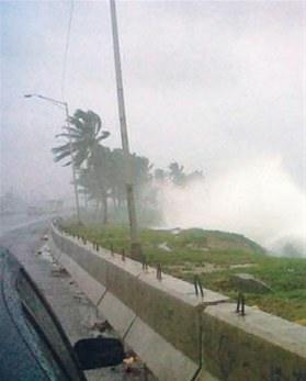
Right: typical photo of a hurricane
Thank you for the picture, Andrew
(was our guest in
Varadero)
We are frequently asked: How are we supposed to behave as a tourist
when we get surprised on the island?
Two simple rules:
1. Stay home.
2. Follow the orders of the Civil Protection authorities.
All our Casas have a solid construction base, none is made of wood.
Hurricane damages
 After the ciclon:
Construction materials are paramount
Oficially a hurricane starts when wind speed exceeds 118 Km/hour. But even at 50 Km persons are adviced to seek protection.
Aus der Schweiz könen Sie Ihre Hilfe für die Opfer direkt an
Cuba-Si Schweiz
leisten.
More about hurricanes in Wikipedia
(This page is searched for and found in the web
as 'hurrican cuba' but also as 'hurricane kuba'.)
Historic Tropical Storms / Hurricane names in 2011: Bret Irene Ophelia Katia
In 2010: Agatha Earl
In 2009: Ana, Hurricane Bill, Claudette, Danny, Fred, Ida
|
 Payments in bitcoins for accommodation in Cuba accepted here.